DR. REET KAMAL TIWARI
Associate Professor
Indian Institute of Technology Ropar
Publications

Glacier area variation in Uttarakhand Himalaya: Investigating trends and influencing factors
Shrivas, I., Guha, S., Tiwari, R. K., Prajapati, M., & Taral, A. L. (2025). Glacier area variation in Uttarakhand Himalaya: Investigating trends and influencing factors. Earth Surface Processes and Landforms, 50(1), e6072. https://doi.org/10.1002/ESP.6072
Hazard, and risk modelling of glacial lakes in the Sikkim Himalaya: Integrating qualitative and quantitative approaches for hazard assessment
Gaikwad, D., Tiwari, R. K., Kumar, M., & Guha, S. (2025). Hazard, and risk modelling of glacial lakes in the Sikkim Himalaya: Integrating qualitative and quantitative approaches for hazard assessment. Geomorphology, 471, 109577. https://doi.org/10.1016/j.geomorph.2025.109577
Development of soil moisture maps using image fusion of SCATSAT-1 and MODIS Dataset
Kaur, R., Maini, R., & Tiwari, R. K. (2025). Development of soil moisture maps using image fusion of SCATSAT-1 and MODIS Dataset. Hyperautomation in Precision Agriculture: Advancements and Opportunities for Sustainable Farming, 169–180. https://doi.org/10.1016/B978-0-443-24139-0.00014-X

Singh, S., Sood, V., Tiwari, R. K., Kaur, R., & Sharma, A. (2024). Endeavours of Scatterometer Satellite (SCATSAT-1) in Earth Exploration: An Overview of Products, Applications and Emerging Trends. Physics and Chemistry of the Earth, Parts A/B/C, 103601
Endeavours of Scatterometer Satellite (SCATSAT-1) in earth exploration: An overview of products, applications and emerging trends
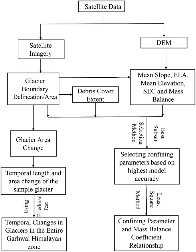
Guha, S., Tiwari, R. K., & Zhang, G. (2024). A Multifaceted Look at Garhwal Himalayan Glaciers: Quantifying Area Change, Retreat, and Mass Balance, and Its Controlling Parameters. Environment, Development and Sustainability, 1-24
A Multifaceted Look at Garhwal Himalayan Glaciers: Quantifying Area Change, Retreat, and Mass Balance, and Its Controlling Parameters

Sunita, Sood, V., Singh, S., Gupta, P. K., Gusain, H. S., Tiwari, R. K., ... & Singh, D. (2024). Estimation and Validation of Snowmelt Runoff Using Degree Day Method in Northwestern Himalayas. Climate, 12(12), 200
Estimation and Validation of Snowmelt Runoff Using Degree Day Method in Northwestern Himalayas

Kumar, M., Tiwari, R. K., Kumar, K., Rautela, K. S., & Safi, S. (2024). Quantitative analysis of hydropower potential in the upper Beas basin using geographical information system and MIKE 11 Nedbor Afrstromnings Model (NAM). Ecohydrology, e2618.
Quantitative analysis of hydropower potential in the upper Beas basin using geographical information system and MIKE 11 Nedbor Afrstromnings Model (NAM)

Mitkari, K. V., Sofat, S., Arora, M. K., & Tiwari, R. K. (2024). Relationship between the variations in glacier features classified on a large scale with climate variables: a case study of Gangotri Glacier. Environmental Monitoring and Assessment, 196(3), 254
Relationship between the variations in glacier features classified on a large scale with climate variables: a case study of Gangotri Glacier

Gaikwad, D., Tiwari, R. K., Kumar, M., & Guha, S. (2024). Hazard, and risk modelling of glacial lakes in the Sikkim Himalaya: Integrating qualitative and quantitative approaches for hazard assessment. Geomorphology, 109577
Hazard, and risk modelling of glacial lakes in the Sikkim Himalaya: Integrating qualitative and quantitative approaches for hazard assessment

Kumar, M., Tiwari, R. K., Rautela, K. S., Kumar, K., Khajuria, V., Verma, I., ... & Elhag, M. (2024). Comparative Assessment of Process Based Models for Simulating the Hydrological Response of the Himalayan River Basin. Earth Systems and Environment, 1-15
Comparative Assessment of Process Based Models for Simulating the Hydrological Response of the Himalayan River Basin

Tyagi, A., Gupta, N., Tiwari, R. K., James, N., & Chavan, S. R. (2024). Determining the impact of anthropogenic activities and climate change on landslide susceptibility for the Himalayan region. Natural Hazards, 1-27.
Determining the impact of anthropogenic activities and climate change on landslide susceptibility for the Himalayan region

Guha, S., Tiwari, R. K., & Pratap, A. (2024). Divergent temporal glacier responses in the Chandra-Bhaga and Suru-Zanskar Basins of the Indian Western Himalaya. Remote Sensing Applications: Society and Environment, 101179.
Divergent temporal glacier responses in the Chandra-Bhaga and Suru-Zanskar Basins of the Indian Western Himalaya

Kaur, R., Tiwari, R. K., & Maini, R. (2024). Detection of Soil Moisture Variations with Fusion-Based Change Detection Algorithm for MODIS and SCATSAT-1 Datasets. Journal of the Indian Society of Remote Sensing, 1-18
Detection of Soil Moisture Variations with Fusion-Based Change Detection Algorithm for MODIS and SCATSAT-1 Datasets

Gaikwad, D., Tyagi, A., & Tiwari, R. K. (2024). Assessing GLOF Hazards in the Himalayas: A Hybrid FR-AHP Approach to Susceptibility Mapping. Remote Sensing Applications: Society and Environment, 101437
Hybrid FR-AHP approach for GLOF hazard assessment in the Himalayan region

Tyagi, A., Tiwari, R. K., & James, N. (2023). Prediction of the future landslide susceptibility scenario based on LULC and climate projections. Landslides, 1-16.
In this study, both dynamic and static factors were utilized in predicting future landslide susceptibility maps for the year 2050.
Tyagi, A., Tiwari, R. K., & James, N. (2023). Identification of the significant parameters in spatial prediction of landslide hazard. Bulletin of Engineering Geology and the Environment, 82(8), 1-13.
this study presents a scientific method to identify the most significant landslide-causing parameters for an enhanced LSM analysis.

Tripathi, A., Moniruzzaman, M., Reshi, A. R., Malik, K., Tiwari, R. K., Bhatt, C. M., & Rahaman, K. R. (2023). Chamoli flash floods of 7th February 2021 and recent deformation: A PSInSAR and deep learning neural network (DLNN) based perspective. Natural Hazards Research.
This study utilizes Persistent Scatterer SAR interferometry (PSInSAR) technique to map the surface displacement of the 2021 flood scenario and make predictions for future displacement using a Deep Learning Neural Network (DLNN) model.

Kumar, M., Tiwari, R. K., Kumar, K., & Rautela, K. S. (2023). Statistical evaluation of snow accumulation and depletion from remotely sensed MODIS snow time series data using the SARIMA model. AQUA-Water Infrastructure, Ecosystems and Society, 72(3), 348-362.
This research highlights the potential of utilizing satellite data and statistical modeling to address the challenges of monitoring snow cover in remote and inaccessible regions.

Kaur, R., Tiwari, R. K., Maini, R., & Singh, S. (2023). A Framework for Crop Yield Estimation and Change Detection Using Image Fusion of Microwave and Optical Satellite Dataset. Quaternary, 6(2), 28.
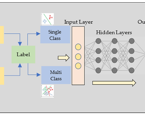
In the present work, a machine learning-based framework is proposed to generate the enhanced resolution soil moisture products, i.e., classified maps and change maps, using an optical-based moderate resolution imaging spectroradiometer (MODIS) and microwave-based scatterometer satellite (SCATSAT-1) datasets.

Guha, S., & Tiwari, R. K. (2023). Analyzing geomorphological and topographical controls for the heterogeneous glacier mass balance in the Sikkim Himalayas. Journal of Mountain Science, 20(7), 1854-1864.
In the current study, the reason for heterogeneous mass balance has been explained in quantitative methods using a multiple linear regression model in the Sikkim Himalayan region.

Kumar, M., Tiwari, R. K., Kumar, K., & Rautela, K. S. (2023). Prioritization of Sub-watersheds for the Categorization of Surface Runoff and Sediment Production Rate Based on Geo-spatial Modeling and PCA Approach: A Case from Upper Beas River, Himachal Pradesh, India. Journal of the Geological Society of India, 99(4), 545-553.
A geo-spatial model and principal component analysis (PCA) approach are used in this study to prioritize sub-watersheds of the upper Beas river up to Pandoh dam.
Singh, S., Tiwari, R. K., Sood, V., Kaur, R., Singh, S., & Prashar, S. (2022). Estimation and validation of standalone SCATSAT-1 derived snow cover area using different MODIS products. Geocarto International, 37(27), 18474-18490.
In the present work, the scatterometer satellite (SCATSAT-1) has been implemented and validated to provide the near-real-time estimation of snow cover area (SCA) in the Western Himalayas, India.
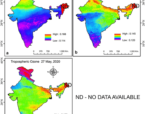
Reshi, A. R., Moniruzzaman, M., Tripathi, A., Tiwari, R. K., & Rahaman, K. R. (2022). A remote sensing based study of tropospheric ozone concentration amid COVID-19 lockdown over India using Sentinel-5P satellite data. Geocarto International, 1-20. DOI: 10.1080/10106049.2022.2123957
This study aims to estimate the O3 concentration during the Covid-19 lockdown over Pune city in India using freely available Sentinel-5P satellite datasets.

Tyagi, A., Tiwari, R. K., & James, N. (2022). A Review on Spatial, Temporal and Magnitude prediction of Landslide Hazard. Journal of Asian Earth Sciences: X, 100099.
We reviewed 367 articles from 1972 to 2021, out of which 236 articles were reviewed in detail to prepare a literature database.

Tripathi, A. & Tiwari, R. K. (2022). Utilization of Spaceborne C-band dual Pol Sentinel-1 SAR data for simplified Regression-based Soil Organic Carbon Estimation in Rupnagar, Punjab, India. Advances in Space Research, https://doi.org/10.1016/j.asr.2021.08.007
This study utilises time-series, C-band remotely sensed SAR data from Sentinel-1 A satellite for SOC estimation and compared the performances of Random Forest (RF) and Ordinary Least Squares (OLS) Regression models over agricultural areas of Rupnagar district of Punjab in India.
Sood, V., Tiwari, R. K., Singh, S., Kaur, R., & Parida, B. R. (2022). Glacier Boundary Mapping Using Deep Learning Classification over Bara Shigri Glacier in Western Himalayas. Sustainability, 14(20), 13485.
In this study, the deep learning classifier based on ENVINet5 (U-Net) architecture is demonstrated in the delineation of glacier boundaries along with snow/ice over the Bara Shigri glacier (Western Himalayas), Himachal Pradesh, India.

Guha, S., & Tiwari, R. K. (2022). Analysis of differential glacier behaviour in Sikkim Himalayas in view of changing climate. Geocarto International, 1-23.
The present study aims to identify temporal changes in glacier response using area changes, retreat, and surface elevation changes.

Tyagi, A., Tiwari, R.K. & James, N. Mapping the landslide susceptibility considering future land-use land-cover scenario. Landslides (2022). https://doi.org/10.1007/s10346-022-01968-7
The main objective of this study is to predict the future LS map considering the future LULC change scenario for the Tehri region, India.

Singh, S., Tiwari, R. K., Sood, V., Kaur, R. & Prashar, S. (2021). The Legacy of Scatterometers: Review on Applications and Perspective. IEEE Geoscience and Remote Sensing Magazine. DOI: 10.1109/MGRS.2022.3145500.
The paper presents the comprehensive review of the scatterometer, as an active microwave radar sensor

Tripathi, A., & Tiwari, R. K. (2022). Synergetic utilization of sentinel-1 SAR and sentinel-2 optical remote sensing data for surface soil moisture estimation for Rupnagar, Punjab, India. Geocarto International, 37(8), 2215-2236.
This study utilizes Sentinel 1 A, C-band SAR remote sensing data with VV and VH polarization channels for surface soil moisture estimation for alluvial soil and its sub-types in Rupnagar of Punjab state in India.

Mitkari, K. V., Arora, M. K., Tiwari, R. K., Sofat, S., Gusain, H. S., & Tiwari, S. P. (2022). Large-scale debris cover glacier mapping using multisource object-based image analysis approach. Remote Sensing, 14(13), 3202.
This paper presents the spectral and spatial capabilities of OBIA to classify multiple glacier cover classes using a multisource approach by integrating multispectral, thermal, and slope information into one workflow.

Tripathi, A., Tiwari, R. K., & Tiwari, S. P. (2022). A deep learning multi-layer perceptron and remote sensing approach for soil health-based crop yield estimation. International Journal of Applied Earth Observation and Geoinformation, 113, 102959.
This study aims to utilize remotely sensed Microwave satellite data from Sentinel-1 and optical data from Sentinel-2, and field data to estimate three important soil health parameters- Soil Moisture, Soil Salinity, and Soil Organic Carbon (SOC). The study has been carried out in the Rupnagar district of Punjab in India. The estimated soil health parameters, SAR backscatter, and optical remote sensing satellite data parameters were utilized to estimate wheat crop yield.

Pandey, A. C., Ghosh, T., Parida, B. R., Dwivedi, C. S., & Tiwari, R. K. (2022). Modeling Permafrost Distribution Using Geoinformatics in the Alaknanda Valley, Uttarakhand, India. Sustainability, 14(23), 15731.
To assess the spatial distribution of permafrost in the Alaknanda Valley of the Chamoli district of Uttarakhand state, 198 rock glaciers were mapped (183 active and 15 relict) using high-resolution satellite data available in the Google Earth database.

Tripathi, A., & Tiwari, R. K. (2022). Synergetic utilization of sentinel-1 SAR and sentinel-2 optical remote sensing data for surface soil moisture estimation for Rupnagar, Punjab, India. Geocarto International, 37 (8), 2215-2236.
This study utilizes Sentinel 1 A, C-band SAR remote sensing data with VV and VH polarization channels for surface soil moisture estimation for alluvial soil and its sub-types in Rupnagar of Punjab state in India.
Tripathi, A., Reshi, A. R., Moniruzzaman, M., Rahaman, K. R., Tiwari, R. K. and Malik, K., (2022) "Interoperability of C-band Sentinel-1 SAR and GRACE satellite sensors on PSInSAR based urban surface subsidence mapping of Varanasi, India," in IEEE Sensors Journal, 2022, doi: 10.1109/JSEN.2022.3208117.
This study aims to correlate the PSInSAR average surface line of sight (LOS) displacement from Sentinel-1, with the average groundwater fluctuations from the GRACE sensor temporally from May 2017 to February 2022.

Singh N, Shekhar M, Parida BR, Gupta AK, Sain K, Rai SK, Bräuning A, Singh Charkaborty J, Sharma V, Tiwari R. K., Chauhan P and Montagnani L (2022) Tree-Ring Isotopic Records Suggest Seasonal Importance of Moisture Dynamics Over Glacial Valleys of the Central Himalaya. Front. Earth Sci. 10:868357.
Our results indicate that attribution of ice mass to large-scale dynamics is likely to be modulated by local vegetation changes. This study contributes to the understanding of long-term hydroclimate—ice mass variability in the central Himalaya, where predictions are crucial for managing water resources and ecosystems.

Tripathi, A., & Tiwari, R. K. (2022). Utilisation of spaceborne C-band dual pol Sentinel-1 SAR data for simplified regression-based soil organic carbon estimation in Rupnagar, Punjab, India. Advances in Space Research, 69(4), 1786-1798.
This study utilises time-series, C-band remotely sensed SAR data from Sentinel-1 A satellite for SOC estimation and compared the performances of Random Forest (RF) and Ordinary Least Squares (OLS) Regression models over agricultural areas of Rupnagar district of Punjab in India.
Singh, S., Tiwari, R. K., Sood, V., Gusain, H. & Prashar, S. (2021). Image-Fusion of Ku-band based SCATSAT-1 and MODIS data for Cloud-free Change Detection over Western Himalayas. IEEE Transactions on Geoscience and Remote Sensing. vol. 60, pp. 1-14, 2022, Art no. 4302514
This study has been conducted over the Western Himalayas to estimate the snow cover changes under cloudy conditions with two datasets, i.e., winter and monsoon.

Singh, S., Tiwari, R. K., Sood, V., & Gusain, H. S. (2021). Detection and validation of spatiotemporal snow cover variability in the Himalayas using Ku-band (13.5 GHz) SCATSAT-1 data. International Journal of Remote Sensing, 42(3), 805-815.
The present study evaluates the potential of Ku-band Scatterometer Satellite-1 (SCATSAT-1) for quantification of spatiotemporal variability in snow cover area (SCA) over Himalayas (Himachal Pradesh) India.

Tripathi, A., & Tiwari, R. K. (2021). A simplified subsurface soil salinity estimation using synergy of SENTINEL-1 SAR and SENTINEL-2 multispectral satellite data, for early stages of wheat crop growth in Rupnagar, Punjab, India. Land Degradation & Development, 32 (14), 3905– 3919.
This study aimed to estimate subsurface soil salinity (at 60 cm depth) for the early stage of wheat crop growth in a simplified manner using freely available satellite data, which is a novel feature and prime objective in this study.

Tripathi, A., Attri, L., & Tiwari, R. K. (2021). Spaceborne C-band SAR remote sensing–based flood mapping and runoff estimation for 2019 flood scenario in Rupnagar, Punjab, India. Environmental Monitoring and Assessment, 193(3), 1-16.
This study uses space-borne SAR data in C-band with VV (vertically emitted and vertically received) and VH (vertically emitted and horizontally received) polarization channels from Sentinel-1A satellite for SAR interferometry-based flood mapping and runoff modeling for Rupnagar (Punjab) floods of 2019.

Singh, N., Singh, J., Gupta, A. K., Bräuning, A., Dimri, A.P., Ramanathan, A.L., Sharma, V., Tiwari, R. K., Chakraborty, J. S., Chauhan, P., Shukla, T., Singhal, M., Rawat, R., Agarwal, S., and Raja, P., (2021) “Climate-driven acceleration in forest evapotranspiration fueling extreme rainfall events in the Himalaya. Environmental Research Letters, 16(8), 084042. https://doi.org/10.1088/1748-9326/ac14ed (Corresponding Author).
In this study, utilizing results of about three centuries of cellulose isotope chronologies (δ13C and δ18O) of dominant tree species, geo-chronological proxies, bio-geophysical dataset and simulations including satellite observations, we show an activation in the ecophysiological processes including evapotranspiration (ET) since the 1950s.

Singh, S., Tiwari, R.K., Sood, V. & Prashar, S. (2021) Fusion of SCATSAT-1 and optical data for cloud-free imaging and its applications in classification. Arabian Journal of Geosciences 14, 1978.
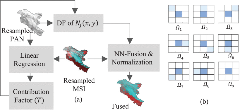
In the present work, the microwave-based SCATSAT-1 and optical-based MODIS (moderate resolution imaging spectroradiometer) have been fused using the nearest-neighbour approach to examine its effects in cloud removal and its applications in classification.

Singh, S., Tiwari, R. K., Gusain, H. S., & Sood, V. (2020). Potential applications of SCATSAT-1 satellite sensor: a systematic review. IEEE Sensors Journal, 20(21), 12459-12471.
This paper aims to address the current status of SCATSAT-1 applications in different scientific domains such as oceanographic, cryospheric, agriculture and land hydrology.

Saini, V., and Tiwari, R.K. (2020) “A systematic review of urban sprawl studies in India: A geospatial data perspective”, Arabian Journal of Geosciences, 13(17), pp.1-21.
This paper reviews articles published in the English language and using geospatial data in analysing the state of urban sprawl in India.

Saini, V., and Tiwari, R.K. (2019). Remote sensing-based time-series analysis for monitoring urban sprawl: A case study of Chandigarh capital region. Journal of Geomatics, 13(1): 94-97.
In the present study, a supervised classification applied to a time-series data of Landsat collected over time (1990, 2001, and 2015) gave an insight into the urban sprawl patterns in the Chandigarh capital region.

Mitkari, K., Arora, M. K. and Tiwari, R. K., (2017) Extraction of Glacial Lakes in Gangotri Glacier Using Object-Based Image Analysis,” IEEE Journal of Selected Topics in Applied Earth Observations and Remote Sensing, Volume 10 (12), pp 5275-5283.
In this study, we used a novel approach, known as object-based image analysis (OBIA), for the mapping of SGLs. A new index has also been proposed for classification of SGLs. As a case study, the SGLs of Gangotri glacier (Uttarakhand Himalayas) have been mapped from the high spatial resolution data of LISS-IV using the proposed OBIA approach.

Garg, P.K., Shukla, A., Tiwari, R. K. and Jasrotia, A. S., (2017) Assessing the status of glaciers in part of the Chandra basin, Himachal Himalaya: A multiparametric approach,” Geomorphology, Volume 284, pp 99-114.
This study investigates the change in multiple glacier parameters of three valley-type glaciers (Sakchum (SC), Chhota Shigri (CS), and Bara Shigri (BS)) located in Chandra basin, Himachal Himalaya, sharing the same climatic regime, and assesses the control of nonclimatic factors on wholesome glacier response.

Chauhan, P., Chauniyal, D. D., Singh, N. and Tiwari, R. K., (2016) Quantitative geo-morphometric and land cover-based micro-watershed prioritization in the Tons river basin of the lesser Himalaya," Environmental Earth Sciences, Vol. 75(6), pp. 498.
In this study, a typical sub-watershed of the lesser Himalaya (Tons sub-watershed: TSW) has been selected for prioritizing its micro-watershed and proposing a suitable and sustainable site for a small hydro-water plant installation.

Ahluwalia, R. S., Rai S. P., Gupta, A. K., Dobhal D. P., Tiwari, R. K., Garg, P. K., Kesarwani, K., (2016) "Towards the understanding of the flash flood through isotope approach in Kedarnath valley in June 2013, Central Himalaya, India," Natural Hazards, Volume 82(1), pp 321-332.
Understanding of the flash flood through isotope approach in Kedarnath valley in June 2013